
According to the World Economic Forum’s report on digital transformation in oil & gas, predictive maintenance stands to unlock $150 billions of value for the industry.1 If you’re a pipeline operator, this manifests as a radical reduction of costs and a vast improvement to operational efficiency. Predictive maintenance exploits both real-time and historical data to evaluate potential threats and prioritize where resources are best applied to prevent failures.
Predictive maintenance programs are built on high-quality data around your pipeline operation. Enterprise platforms for aerial data give you the tools you need – such as Unmanned Aerial Vehicles (UAVs) and Artificial Intelligence (AI) – to visualize your asset in a way that allows you to better detect several integrity hazards and contextualize your in-line sensor readings. Ultimately, the insights you yield from this process can be used to inform an effective predictive maintenance program.
Here are the 5 midstream pipeline hazards that you can start to prevent with aerial data analytics:
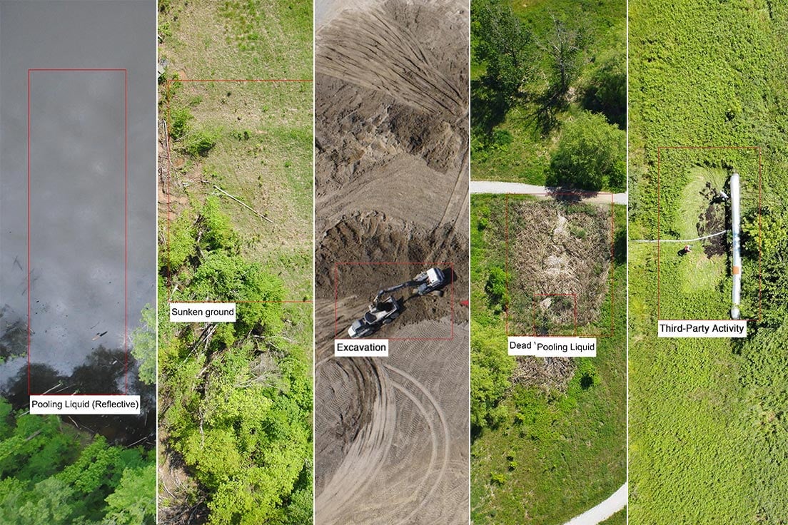
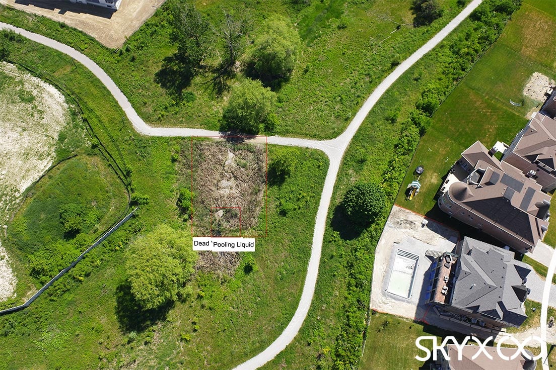
1. Pipeline Failures & Spills
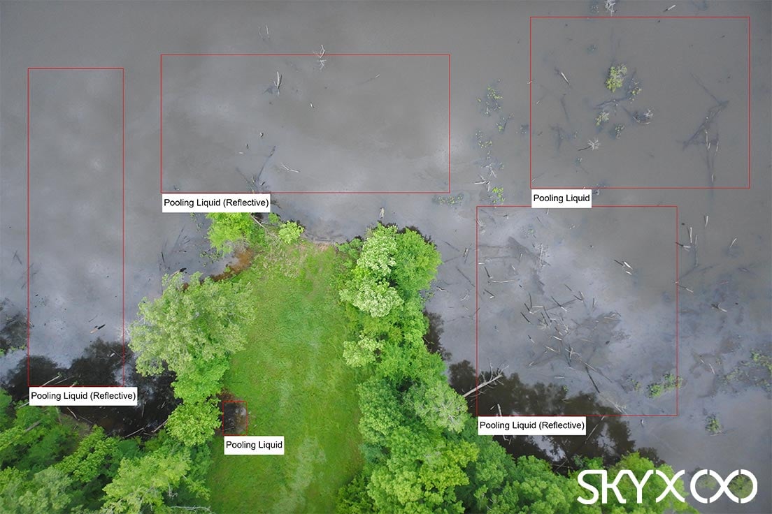
UAVs are able to source imagery with incredible spatial resolution and accuracy, and from these images, a multi-category anomaly detector can spot the signs of a failure. These include pools of oil, gas plumes, abnormal ground discolouration, dying vegetation, and oil slicks in bodies of water.
All of these anomalies can be spotted via standard RGB imagery, but there are a variety of specialized UAV sensors that can help you be 100% sure. For instance, say there’s a strange-looking patch of ground coloration along your ROW, but you’re not quite sure it’s a spill. With an infrared sensor and its thermal imagery, you can identify specific changes in ground temperature that can verify whether it’s actionable.
Not only does an aerial data platform help you identify failures & spills that may otherwise go unnoticed by your in-line systems, but it also improves how you interpret those in-line readings. Given that SCADA sensors are commonly located between vast segments of pipe, SCADA alerts can be extremely vague on location. An aerial platform can serve as an automated first response to an alert, providing valuable visual verification data for your maintenance crew.
2. Geotechnical Anomalies
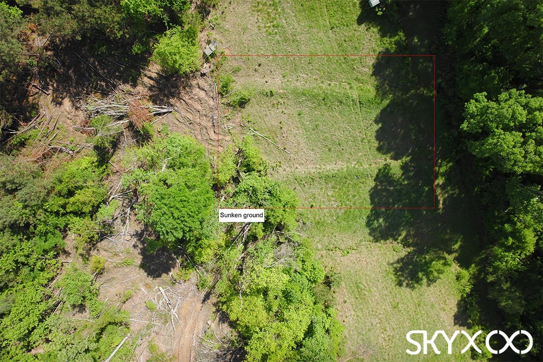
Many midstream pipeline operators struggle to get in front of damage resulting from movement of the ground along their ROW. Geotechnical hazards such as erosion, landslides, and sinkholes that can expose or impact the pipe tend to go unnoticed until it’s too late. With an aerial data platform, you can track these issues with laser precision, literally!
A UAV can be outfitted with Light Detection and Ranging (LiDAR) sensors that utilize laser pulses to measure the ground surface below. From these measurements, you can generate point clouds and Digital Elevation Models (DEMs) that provide accurate 3D models of your ROW surface and terrain. In this instance, a full convolutional differential detector model can take on the burden of measuring the change in ground surface between inspections and notify you when something significant is happening. This form of change detection analysis is incredibly valuable for detecting a variety of other issues.
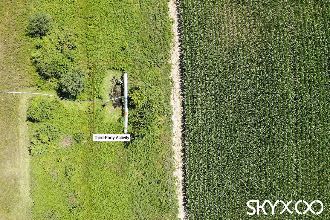
3. Unauthorized Third-Party Activity
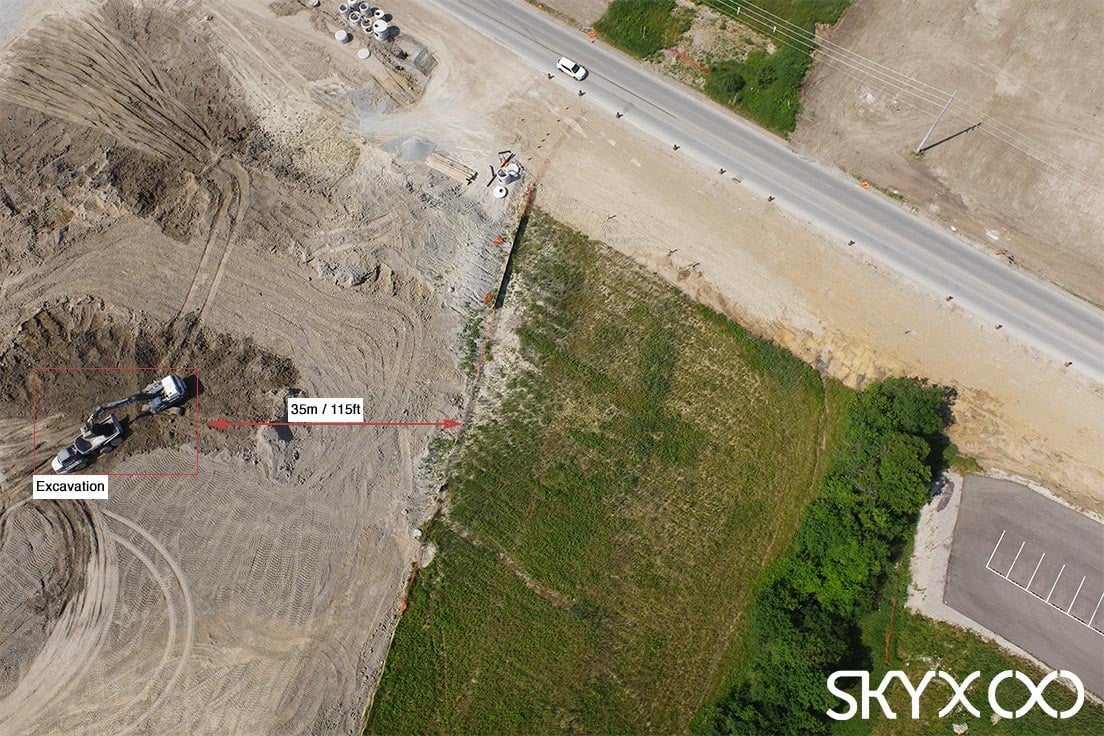
Another major external hazard that an aerial data platform is well-suited to help you mitigate. Year-over-year, PHMSA’s Significant Incident Report shows that third-party excavation continues to be one of the most persistent threats to pipeline safety. Why is this? The traditional in-line technologies you likely rely on, will only notify you after damage has already occurred. You may contract manned aerial inspections for this very reason, but these inspections usually don’t happen with the frequency needed to reliably identify these issues.
An aerial data platform can bring this reliability to your visual monitoring efforts, through automation. With an autonomous UAV flying your ROW on a routine basis, and AI utilizing simple object detection and classification techniques on the imagery, you stand a much greater chance of spotting these issues while you can still take action to avert damage.
4. Environmental Health
Through the same object and classification analysis we’ve described above, AI can log instances of wildlife sightings or indications of wildlife harassment – such as the presence of hunting camps on the ROW or construction activity disrupting the environment.
Aerial data also makes vegetation management a much more straightforward affair. With the same LiDAR data we spoke of before, you can create accurate 3D models of vegetation canopies around your right-of-way. A change detection system can analyze the growth of vegetation from inspection-to-inspection, formulate a rate of expansion, and notify you when and where unacceptable levels of encroachment are going to occur.
With the right sensor insights, you can use the vegetation around your ROW as a barometer for your pipeline integrity. Spectral sensors observe how objects absorb and reflect light, which in the aerial survey world, allows for the assessment plant health based on their photosynthetic activity. AI can use this sensor data to identify abnormal clusters of distressed vegetation along your ROW that may signal a recent spill.
5. Pipeline Product Theft
In recent years, illegal tappers have adopted careful theft methods proven to evade traditional leak detection technologies. If you’re trying to combat theft along your pipeline, read our blog article on Sophisticated Solutions for Sophisticated Pipeline Product Theft for a thorough analysis of why aerial data platforms are the premier anti-theft solution for your pipeline.
The actionable data points you gain from collecting aerial data on an ongoing basis help you understand how potential issues are developing and trending along your right of way.
Have questions about how high-quality aerial data can elevate your organization?
Contact our team to discuss your unique challenges and data requirements.
References
- Digital Transformation Initiative – Oil and Gas Industry, World Economic Forum, 2017